I work at the intersection of urbanization patterns, local energy policy and equity. In my research, I seek to understand the motivations, intentions and plans of multiple actors endowed with limited capabilities, imperfect foresight and distributed authority, in urban settings. Lately, I have been studying these issues in the context of local energy planning. I routinely use high cadence, large geospatial and temporal datasets and novel quantitative methods in my research. I am also a planning theorist, specialising in organisational decision-making, institutional restructuring and the role of plans. In addition to my faculty appointments in the City & Regional Planning and the Environment, Ecology & Energy program at the University of North Carolina at Chapel Hill, I am a faculty research fellow at the Center for Community Capital and faculty fellow at the Insitute for the Enviroment and the Center for Urban and Regional Studies.
PhD in Regional Planning, 2008
University of Illinois at Urbana Champaign
MS in Applied Mathematics, 2007
University of Illinois at Urbana Champaign
MUP in Urban Planning, 2004
University of Illinois at Urbana Champaign
BArch(Hons.) in Architecture, 2001
Indian Institute of Technology at Kharagpur
Free form text is ubiquitous in planning, including plans, regulations, meeting minutes, and transcripts, etc. This is a short introduction to analysing such text quantitatively.
The following is a transcript for a podcast as part of the series called “Viewpoints on Resilient and Equitable Responses to the Pandemic” produced by Center for Urban and Regional Studies. In March 2020, the New York Times reported on a smartphone application that is being rolled out in Hangzhou, China in response to the COVID-19 pandemic. The Alipay Health Code, as China’s official news media has called the system, is a project by the local government with the help of e-commerce giant Alibaba.
In 2018, as I was setting up this website, I had a conversation about land suitabilty analysis over email with Lew Hopkins, who was my doctoral advisor when I was at Illinois. I want to capture this conversation on this site, as a caveat, instead of sitting in my Inbox. The emails are slightly edited. Lew, I am in the process of getting some blog posts up regarding planning methods and I was imagining writing one about land suitability analysis.
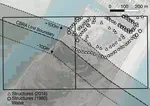
Urban development relies on many factors to remain viable, including federal assistance with infrastructure development. The 1982 US Coastal Barrier Resources Act (CoBRA) prohibits federal financial assistance for infrastructure, post-storm disaster relief, and flood insurance in designated sections (system units) of coastal barriers. How has CoBRA’s removal of these subsidies affected rates and types of urban development? Using building footprint and real estate data (n=1,385,552 parcels), we compare density of built structures, land use types, and land values within and outside of system units in eight southeastern US states. Here we show that CoBRA is associated with reduced development rates in coastal barrier zones, but also reveal how withdrawal of federal subsidies might be counteracted by local responses. As attention increases towards improving development policy in high hazard areas, this work contributes to understanding how limitations on infrastructure subsidies can affect outcomes under overlapping jurisdictions with competing goals.
We aim to find agglomerations of U.S. counties that are partitioned by commuting patterns by representing inter-county commuting patterns as a weighted network. We develop and use a community detection method based on the configuration model to identify significant clusters of nodes in a weighted network that prominently feature self-loops which represent same-county commuting. After we apply this method to county level commuting data from 2010, we find regions that are significantly different from existing delineations such as Metropolitian Statistical Areas and Megaregions. Our method identifies regions with varying sizes as well as highly overlapping regions. Some counties belong to as many as six different statistically significant clusters but some do not belong to any. Our results offer an alternative way of categorizing economic regions from existing methods and suggest that geographical delineations should be rethought.
The measurement and characterization of urbanization crucially depends upon defining what counts as urban. According to The Indian Planning Commission, less than a third of the Indian population lives in urban areas, and while Indian cities are increasingly important to the economy, India is perceived fundamentally as a rural country. In this paper, we show that this received wisdom is an artefact of the definition of urbanity and the official statistics vastly undercount the level of urbanization and its importance for development policies in India. We begin by creating temporally-consistent, high-resolution population maps from sub district level population data available from the Indian Census for 2001 and 2011. The modeling framework is a two-step process that applies a Random Forest-based model to generate a prediction weighting layer subsequently used to inform a gridded dasymetric redistribution of original census counts at 100 m resolution (Stevens et al. 2015). We then apply density thresholds, contiguity conditions, distance based clustering and minimum population sizes to construct urban agglomerations for the entire country. Compared to the official estimates, we find that this approach counts 8%-30% (depending on thresholds) more urban population in 2011. We find large urban agglomerations that span large portions of Kerala and the Gangetic plain. Thus, while official estimates count more cities in the country, we delineate fewer cities but large urban regions that span jurisdictional boundaries. This has implication for urban policies.
Categorizing places based on their network connections to other places in the regiom reveals not only population concentration but also economic dynamics that are missed in other typologies. The US Office of Management and Budget categorization of counties into metropolitan/micropolitan central/outlying is widely seen as insufficient for many analytic purposes. In this paper we use coreness index from network analysis to identify labor market centrality of a county. We use county-to-county commute flows, including internal commuting, to identify regional hierarchies. Indicators broken down by this typology reveal counterintuitive results in many cases. Population size and level of urbanisation is largely irrelevant to strong core counties. Employment in these strong core counties grew faster in the post-recession (2008-2015) than other types, that is missed by other typologies, suggesting that this categorization may be useful for regional analysis and policy.
I typically teach the following courses. Sample syllabus and schedules are linked. Please check the course schedules for term and registration information.
From time to time, I offer short courses with differing durations. Stay tuned for updates.