Abstract
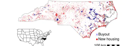
Problem, research strategy, and findings: Limiting housing and infrastructure in flood-prone places has long been recognized as critical to managing long-term risk. However, due to the difficulty of tracking development at small spatial scales, little empirical research has been conducted to explain differences between communities? floodplain development patterns. We analyzed new construction across 5 million parcels in the state of North Carolina to develop standardized measures of floodplain development and evaluated the relationships between flood risk management effort and development outcomes. Statewide, for every property removed through buyouts from 1996 to 2017, more than 10 new residences were built in floodplains. At the community level, indicators of flood risk management effort (participation in the Community Rating System and use of buyouts) did not consistently align with floodplain development outcomes. Based on a sample of urban and suburban counties, we found more than 75,000 acres of vacant floodplain land currently zoned for development. Although we did not capture the full range of flood risk mitigation practices, results indicate that local development policies often run counter to efforts to limit long-term risk. Takeaway for practice: Land use planning and floodplain management have the potential to play a larger role in flood risk mitigation. Modifying federal programs to more strongly disincentivize floodplain development could enhance local regulation and minimize future flood exposure. Given extensive undeveloped floodplain land and projected climate change, additional effort to manage development is needed to limit increases in flood risk.